Published September 14, 2025 03:32AM
A ŌĆśBrand NewŌĆÖ Island Was Just Recorded in Alaska
Home to more than 1,000 glaciers, Southeast AlaskaŌĆÖs Glacier Bay National Park just welcomed its newest island

Glacier Bay National Park encompasses more than 5,000 square miles in Southeast Alaska (Photo: Andrew Peacock/Getty Images)
To get to Glacier Bay National Park, you have to fly or swim. Measuring more than 5,000 square miles, the Southeastern Alaska park is only accessible by air or water, and visitors typically arrive in the area by boat from the tiny nearby town of Gustavus, just outside of AlaskaŌĆÖs capital city, Juneau.
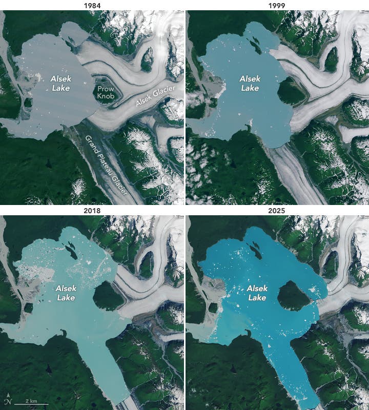
Alaska has just documented a ŌĆ£brand newŌĆØ island in Glacier Bay National Park after floodwater from the nearby Alsek Glacier surrounded a landmass known as Prow Knob.
At nearly 15 miles long, the Alsek Glacier in the park once encompassed the 5-square-mile Prow Knob. However, warming temperatures and increased glacial melt have caused freshwater to replace glacial ice, contributing to the growth of Alsek Lake around the strip of land.
NASA taken between 1984 and 2025 that show how far ice has retreated throughout the decades. In the early 20th century, the glacier ended about 3 miles from Prow Knob. Ice continued to melt throughout the century, and by 1984, the eastern side of Prow Knob had its first documented lakeshore. In August, the lakeshore expanded around the entire perimeter of Prow Knob.
Glaciers rely on snowpack to form and be maintained. As snow falls in the mountains, it compacts into ice and eventually slides downhillŌĆöbut more and more glaciers around the world are melting away. The National Park Service writes that centuries ago, an ŌĆ£enormous glacier, several miles wide and several thousand feet thick, covered most of Glacier Bay National Park.ŌĆØ In the last 250 years, this glacier has retreated 65 miles to form Glacier Bay. Most of the are smaller pieces of the enormous glacier that once filled the region.
Alsek Glacier is just one example showing how glaciers are thinning. In August, residents of Juneau, Alaska, received evacuation warnings after glacial floodwater broke through a dam of glacial ice at Mendenhall Glacier. The , with the peak water level reaching nearly 16 feet.