
Arizona is called the Grand Canyon State for good reason, but that natural wonder is far from the only gem in the state’s public-lands network of hidden alpine lakes, lush rivers, towering red-rock formations, slot canyons, and more. Translation: there’s a slice of Arizona public land perfect for every kind of adventurer, whether you want to stargaze deep in the backcountry or strike out from the city for a day hike.
Kartchner Caverns State Park
Rediscover Arizona
 The Grand Canyon State’s Namesake Park is just the start—in every corner of Arizona, there are public lands and trails for everyone. Want to explore even more of the state’s hidden gems? Check out our complete guide and interactive map for an endless southwestern adventure.
Best for: Seeking darkness above and below ground
Southeast of Tucson in the town of Benson, offers an array of wheelchair-accessible tours of stunning limestone caverns that were kept secret until 1978. One of the coolest: a headlamp tour on Saturdays without any additional artificial light beyond the one you carry with you. Snag a campsite or cabin within the state park to enjoy the darkness above ground, too. Kartchner is one of Arizona’s ten Dark Sky–certified parks, so bring your tripod and a blanket to gawk up at the Milky Way.
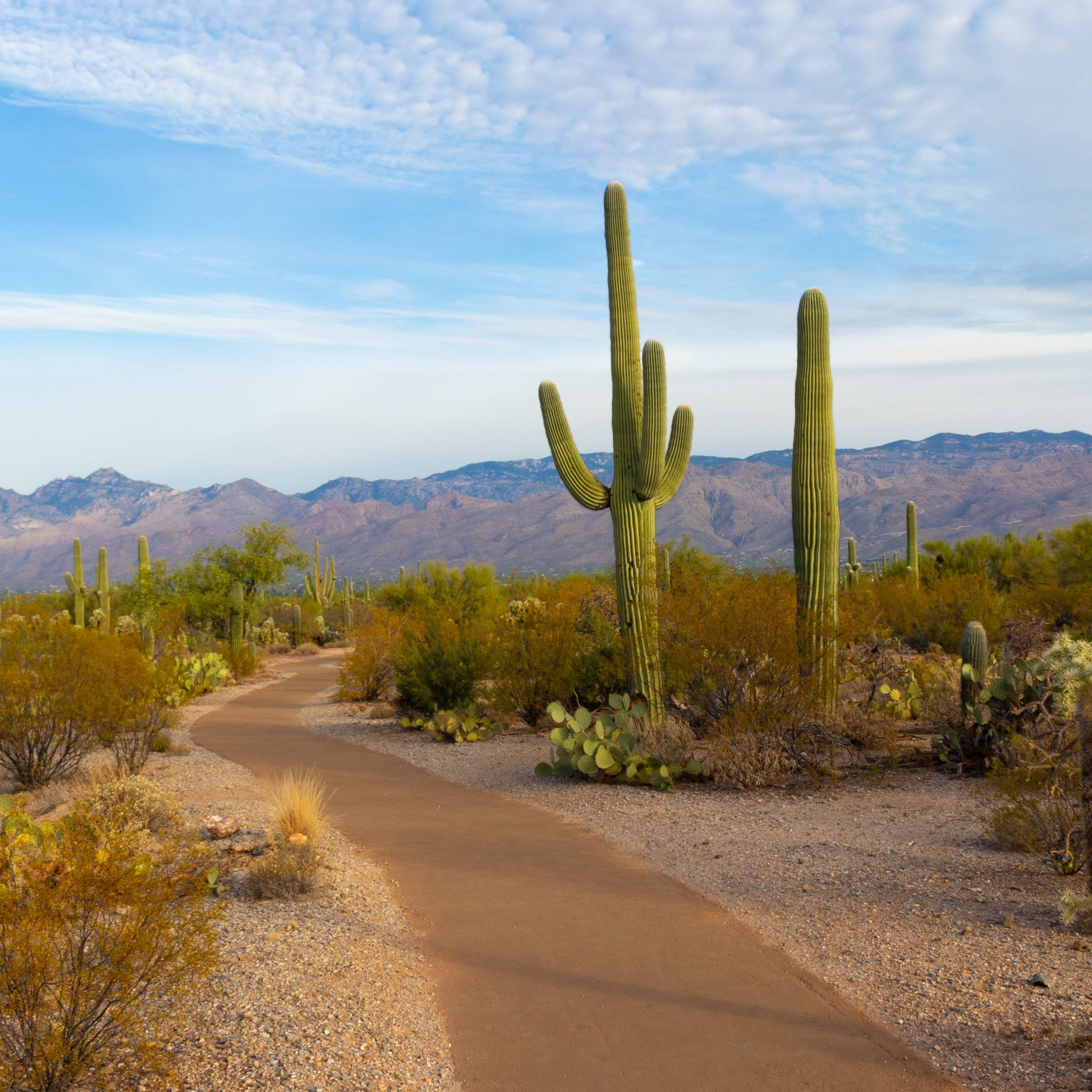
Saguaro National Park
Best for: The giant redwoods of the cactus world
Saguaro cacti exist only in North America, and the Tucson area’s are the biggest in the world. Head to for stunning desert mountain vistas framed by these big-armed plants. Don’t write off the summer months—saguaros start to flower in late April, and they can bloom into early June (plus, the higher elevations in the park’s eastern portion offer surprisingly cool temps). Base-camp in Tucson for southwestern luxury in the city’s resorts, or get a to hike in and pitch a tent.
Vermilion Cliffs National Monument
Best for: Slot-canyon hikes and invoking Insta-envy
is where you’ll find the Wave, aka Coyote Buttes—a smooth and curvy sandstone rock formation that seems to have been painstakingly painted with narrow bands. You’ll need a for this 5.6-mile hike, so be sure to plan ahead. Looking for a serious challenge? Set aside a few days to backpack through Paria Canyon from Buckskin Gulch to Lees Ferry, about 45 miles. You also need a permit for overnight camping in the canyon and, heads up, you’ll need to pack out your poop. Camp at the monument’s developed State Line Campground on—you guessed it—the state line with Utah, or base-camp in nearby Page.
Glen Canyon National Recreation Area
Best for: Zipping across a desert lake on Jet Skis
defies the odds. Here, minutes from the iconic twists of Horseshoe Bend, you’ll find the massive, man-made Lake Powell. Boating is popular here and it’s easy to rent paddling gear or a motorboat in Page, so long as you know how to drive it. The lake has floating restrooms so you can keep the reservoir clean. You can camp in primitive sites on the beaches of Lake Powell near Page, book a hotel in town for exploration around northern Arizona (the magical Antelope Canyon, in the Navajo Nation, is just about half an hour away, though it’s currently closed), or even rent a houseboat to camp right on the lake itself.
Organ Pipe Cactus National Monument
Best for: A family scavenger hunt to identify dozens of different cacti
Along the state’s border with Mexico, offers stunning views and, you guessed it, cactus—31 species, to be exact. Traveling with the family? See how many varieties you can spot along the monument’s trails. Got kids that can’t be trusted so close to sharp and spiny plants? Cruise the scenic Ajo Mountain Drive instead. Always be sure to stock the car with a few gallons of water in case of a breakdown—this classic desert landscape gets hot in summer. Camp in the park for unspoiled night skies or book a room in the nearby artsy town of Ajo.
Imperial Sand Dunes National Recreation Area
Best for: Off-roading, hiking, wild sunsets
Straddling the state’s southwestern borders with California and Mexico, the are like a massive waterless beach, stretching for more than 40 miles. Some of the dunes reach 300 feet tall, and the whole area is ripe for barefoot summits or zipping around on an ATV. Head to Yuma, which the Guinness Book of World Records has designated the world’s sunniest city, for a permit and an ATV rental. Camp in the dunes or head back to town to relax on the banks of the Colorado River. Just make sure you catch sunset here—the panoramic view from the tops of the dunes are worth all the effort of climbing them.
Tonto National Forest
Best for: Spotting wild horses, hiking, and fishing on man-made lakes within easy reach of metro Phoenix
Just because Phoenix doesn’t get much rain doesn’t mean you can’t cool off in lakes and rivers nearby. And the , though it’s packed with saguaro, has both of these. Canyon Lake, about 45 minutes from Phoenix, is one of the smaller lakes along the Salt River and is a great place to paddle beneath cliffs topped with cactus. The lake is home to walleye, catfish, and yellow bass and stocked monthly from November to March with rainbow trout, so be sure to bring your fly rod. The Boulder Recreation Site offers a wheelchair-accessible fishing dock. Much of the Tonto National Forest is within an easy drive of Phoenix, so stay in town for some of the southwest’s best food (think: the best tacos you’ve ever had north of the border).
Monument Valley Tribal Park
Best for: The most scenic desert drives you can possibly imagine
The Navajo Nation spans the northeast corner of Arizona, the southeast corner of Utah, and the northwestern corner of New Mexico, and it encompasses some of the most jaw-dropping landscapes you’ll ever find, period. The sandstone formations of Monument Valley are a sight to behold from miles away, and they’re even more humbling when you camp within the in their shadows. The Nation is currently closed to tourism, but check back about its reopening plans as vaccination programs gain speed nationwide. When you go, make sure to eat at the restaurant within the park for a taste of traditional Navajo cuisine.
Grand Canyon–Parashant National Monument
Best for: Solitude and scenic—but bumpy—roads in a remote corner of the Grand Canyon
You’ve heard of Grand Canyon National Park, but its much lesser-known sister, , is so remote you won’t have to battle any crowds—you’ll likely be able to pitch a tent in the backcountry here without another soul for miles. The monument has no paved roads, no visitor services, and the nearest amenities are in Littlefield, AZ, so you’ll need a four-wheel drive and a solid map to get around. But if scenic drives and solitude are your game, this is the place. One such drive is the road to Whitmore Canyon Overlook, deep within the Grand and just 1,000 feet above the Colorado River. The National Park Service offers a detailed guide to the drive, which takes in the area’s volcanic origins with views of cinder cones and ancient lava flows.
Aravaipa Canyon Wilderness
Best for: A hidden desert oasis great for first-time backpackers and wildlife lovers
In southeastern Arizona, offers a lush hike through desert views without the stifling heat you expect to accompany saguaro—Aravaipa Creek runs year-round. Trails in the area make it easy to customize your hike for a casual couple hours, or leisurely backpacking to nearby campsites (just make sure to get a —they’re required). Keep your eyes peeled for wildlife, as it’s abundant here. You might spot ringtail cats, javelinas, coatimundis, bighorn sheep, and over 200 species of birds. Backpacking not for you? You can find hotel rooms in the nearby towns of Mammoth and Winkelman, or make a day trip from either Phoenix or Tucson.
Chiricahua National Monument
Best for: Geology tripping
In the southeasternmost corner of Arizona, in one of the state’s seven Sky Islands, you’ll find the gravity-defying remnants of volcanic eruptions from 27 million years ago. Known as “the land of the standing-up rocks” by the Apache, was used as a hiding place by Cochise and Geronimo during the Apache Wars in the 1800s. You can take a scenic drive through the park’s spires on a short, paved road suitable for passenger cars, or you can hike—the Ed Riggs, Hailstone, and Echo Canyon Trail is one of the park’s easier strolls, with about 580 feet of elevation gain over a 3.6-mile loop. Serious geology buffs will geek out about the formations here, so study up in advance with the monument’s rather thorough to get excited in advance of your trip. The monument offers camping but is also an easy day trip from Tucson or Willcox.
’s mission is to stabilize and strengthen Arizona’s economy through travel and tourism promotion. They strive to enhance the state economy and the quality of life for all Arizonans by expanding travel activity and increasing related revenues through tourism promotion and development.