
What exactly happened to six climbers on Mount Rainier who were reported missing on May 30 and are presumed dead remains a mystery, but clues have emerged that strongly suggest an avalanche from above swept them away in the night.
The team, four clients and two guides from Seattle-based , set out on the 14,410-foot volcano’s challenging Liberty Ridge route on Monday, May 27. According to climbing ranger Peter Ellis, this advanced route typically takes teams between three and five days to complete. Guided by Rainier veterans Matt Hegeman, 38, who’d climbed the mountain more than 50 times, and Eitan Green, 29, who started guiding the mountain shortly after graduating from Colby College in 2009, the group made their approach up the Carbon Glacier on Tuesday.
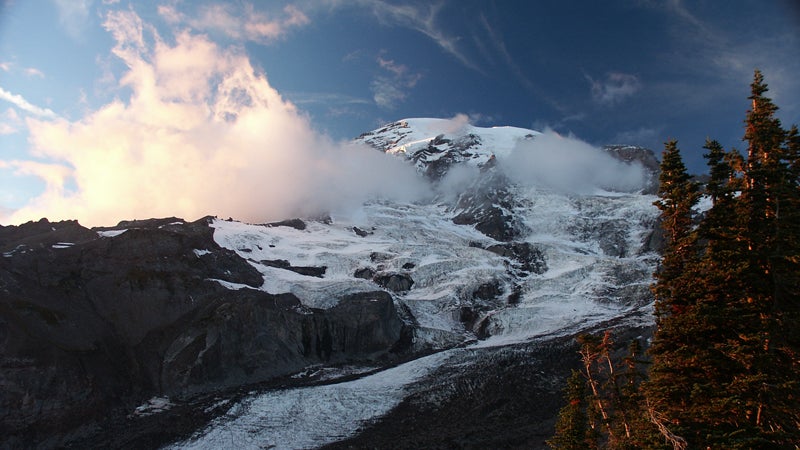
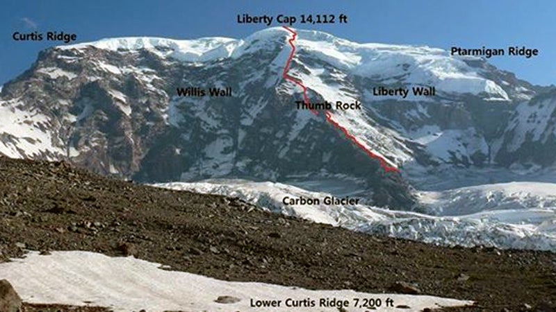
The route itself is a 5,000-vertical foot direttissima of Rainier’s heavily glaciated north face. To the looker’s left of the ridge is the Willis Wall. Hanging over most of the route is the Liberty Cap, a glacier that regularly sheds ice down the mountain. The Liberty Ridge itself, like a dormer on a pitched roof, tends to shed icefall away from the route, but it’s not immune.
During the day on Wednesday, the six were spotted by a private party climbing behind them. Depending on the terrain and the strength of the group, the guided climbers may have been simulclimbing—moving together on the same rope—or belaying each other on each pitch, a technique that’s safer but much more time consuming.
“As you’re approaching, you can see up onto the route and see other climbers,” says NPS’s Peter Ellis. “So as this team was approaching Liberty Ridge they saw [the Alpine Ascents team] at Thumb Rock.”
Thumb Rock is formed by a prominent totem of hardened lava at around 10,700 feet and typically serves as high camp. The Alpine Ascents team had stayed there Tuesday night and headed toward the summit in clear weather on Wednesday morning, though conditions would deteriorate that day. Managers at Alpine Ascents believe the team continued on to an area around the Black Pyramid, where the steeper snow and ice pitches begin.
At 6:20 P.M. the guides made a satellite phone call back to the office, telling guide manager Melanie Hodgman that they were going to camp and see if the weather improved by morning. That was the last the Alpine Ascents office heard from the team. But two of the clients also sent out messages that were received by friends. At about 7 P.M. one climber texted a photo of the Wednesday-night camp to a friend, which was shown to Alpine Ascents co-owner Todd Burleson on Sunday.
“Out of nowhere I get a photograph of this camp and it’s very structured camp,” says Burleson, 54, Alpine Ascents founder. “I can’t see around it ‘cause it’s whiteout, but I see the ridge it’s on. It’s on a nice platform. They’ve got three tents set up.”
It appeared as if they’d already climbed to the top of the Black Pyramid, which would have meant most of the route’s difficulty and elevation was behind them.
Another member of the team also sent out a message from a SPOT tracking device at around 7:45 P.M, though there’s been no indication that it was a distress call. The standard SPOT device’s default message is an All-OK signal that includes a GPS locator pin. In this case that pin showed that the camp was somewhere between 12,400 feet and 12,800 feet, not a typical camping spot on the route but not necessarily a cause for concern. Based on the photo and the SPOT pin, Burleson and his office staff have been trying go figure out exactly where the camp might have been.
“You know, it kinda doesn’t make sense,” says Burleson. “I can’t quite figure this out because there’s no place that looks this good at the top of the Black Pyramid. It only makes sense if they were closer to 12,400 feet.”
What happened in the night requires some speculation. In the most likely scenario, rock or icefall from the Liberty Cap, or possibly a soft avalanche triggered by the isolated snowfall that day, swept down from above and carried the team—asleep in their tents—to the looker's right side of the Willis Wall. On Thursday, the private party (NPS hasn’t identified them) that had spotted Alpine Ascents climbed to the summit and saw no further sign of the team.
That same day, Ellis and rangers Dan Veenhuizen and Scotty Barrier happened to be on a routine patrol on Liberty Ridge. “Thursday we set off and then camped out on Curtis Ridge on Thursday night,” says Ellis. “Friday we moved up to Thumb Rock. And then Saturday morning we made a routine radio call to Camp Sherman to let them know that we were moving up the route. And at that point they informed us that this party had indeed not come back and they instructed us to carry on climbing the route, but to search as we climbed—to stop and take pictures, look for clues, and move slowly looking for any sign of an incident.”
The rangers didn’t find anything. It wasn’t until a helicopter made a low pass over a prominent avalanche debris field at the base of the Willis Wall that they were able to pick up signals from the avalanche beacons that all six climbers were wearing. Some gear and unfurled tents were also visible in the debris. Because that zone is in a funnel that receives ice and rockfall from several highly active avalanche chutes leading down from the summit, it was deemed too dangerous to put people on the ground to dig them out. While some reports have suggested that climate change might be to blame, Ellis thinks conditions are pretty normal.
“The summers on the Willis Wall are always active as far as rock fall and icefall, and as long as I’ve been here in this park that zone has always been notorious,” says Ellis. “So I don’t think that it’s any different from the past decade or so.”
The names of the four clients haven’t been released, but , and the tech giant has confirmed, that one man was Intel vice president Uday Marty, 40, and a second was 26-year-old Mark Mahaney, from Saint Paul, Minnesota. Green and Hegeman were experienced guides for Alpine Ascents, which also has a prominent international guiding business best known for its Himalayan climbs. AAI lost five climbing Sherpas in the April 18 Everest avalanche—that mountain’s deadliest day.
According to NPS spokeswoman Fawn Bauer, rangers will continue to make overflights of the debris field as time allows. “What that means is as we have available aircraft in the air on other missions we will spend time checking out that area,” says Bauer. “The same is true for any kind of foot patrol.”
This is the worst accident on Rainier since on the Ingraham Glacier in June of 1981.