A Bird’s Eye Tour of Our National Parks

When I was young, I had a habit of poring through national park books, fantasizing about visiting them all. Now I’m a part-time aerial adventure photographer, and I’ve been able to fly my Piper PA-11 Cub Special plane over many of the places I used to daydream over.
In a few instances, I have made it a point to fly over a park. But many of my best national park shots happen on unplanned trips. While in pursuit of another item to photograph from the air, I happen to find myself flying through one of the national parks. Distraction takes over and I forget about my initial project.
Since we’re celebrating the national parks centennial, these are some favorite shots that I’ve taken over the last four years. I like the aerial perspective as it’s a fast track to seeing the full magnitude of a park’s beauty. I continue to find unbelievable hidden places inside the park system from the air.
Photo: On this particular morning in September 2015, I was hoping to photograph nine peaks over 14,000 feet (five of them are viewable on the horizon where the clouds touch the peaks). Approaching from the airport in Alamosa, Colorado, the entire scene was shadowed by the rising sun, and I was convinced the entire exercise was going to be a waste of time. As I rode the winds to gain altitude over the Sangre de Cristo Range foothills, attempting to get a good angle on four fourteeners behind me, this panorama opened up.
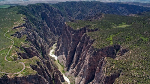
The Gunnison River has its headwaters in some of the highest terrain in Colorado, beginning at the Continental Divide as the race to the Sea of Cortez begins. The canyon’s drop is precipitous, so it is kind of scary to be flying at the exact point where this photo was taken. It feels as though the canyon will swallow the airplane whole.
From the book “Where the Colorado River is Born.”
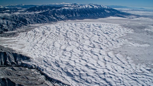
For those who visit Great Sand Dunes National Park in the summer tourist season with sand temperatures approaching 140 degrees, it’s hard to believe the place ever gets cold. The San Luis Valley of Colorado can indeed be one of the coldest areas of the country in winter, trapped in powerful inversions of cold air.
On this particular February afternoon, the dunes were covered in a layer of snow as I wore double layers of ski gear, sticking the camera out the window in temperatures of minus 20 degrees in pursuit of fourteeners on the horizon.
From the book “Above the Summit: An Antique Airplane Conquers Colorado’s Fourteeners.”
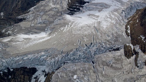
Three days before taking this photograph, I had completed photography of Bighorn Glacier in Wyoming and was thoroughly worn out. On the flight home I said to myself, “There is no way I am going to Glacier National Park this year, I am just too tired.” However, the draw to capture every glacier in the U.S. Rockies was so strong that a few days later, I was wandering around Glacier National Park in Montana, capturing scenes that will never look the same in our lifetimes. Scientific projections indicate that this and all other glaciers in the namesake park will be gone by 2030.
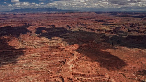
For my project, “The Other Half of the Colorado River,” I was intent on following the Green River from its glacial headwaters in the Wind River Range of Wyoming to its confluence with the Colorado River in Canyonlands National Park. In a few hundred miles, terrain transitions from some of the biggest glaciers in the U.S. Rockies, through verdant and thick forests, and eventually into hot and dry desert as seen above.
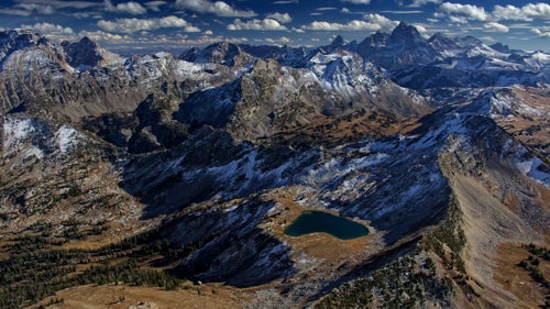
Grand Teton National Park, while not particularly enormous in surface area, has a tremendous density and variety of terrain, from glaciers to massive lakes, and of course Grand Teton herself (13,770’, right horizon). On this particular flight after some early season snowfall, I decided to head into the difficult-to-reach northwest corner of the park to photograph scenes that few visitors will ever see. What I had to get over was the worry of an in-flight emergency in this wilderness, though the resulting photography was every bit worth it.
Longs Peak (14,259’) in Rocky Mountain National Park is usually full of surprises in the airplane. Situated where the Rockies meet the Great Plains, the mountains in this area of Colorado not only hold what few glaciers remain in the state, they are also fantastic wind- and weather-makers. The forecast called for full sunshine, though like the other times I have flown around this peak, there were beautiful and mystifying cloud formations forming around the mountain.
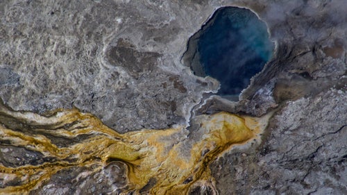
The most difficult photography of the national parks thus far has been the hot springs of Yellowstone. Their deepest secrets are visible directly overhead: The entire bacterial film from drainage paths as well as the core of the hot spring can be seen only from above. Attempting the same on the ground would result in edges of the spring crumbling, and serious injury or death from third-degree burns. The entire prospect is very challenging with a zoom lens, Yellowstone’s frequent turbulence, and an aircraft moving faster than a speeding car.
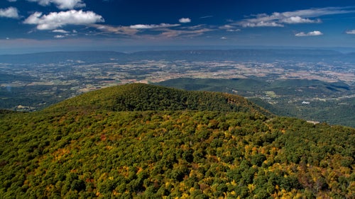
The Blue Ridge Parkway continues on as Skyline Drive through Shenandoah National Park, both roads of which are works of art as viewed from the air. I have traversed the Shenandoah Valley many times in the plane, and each time it was incredibly peaceful and beautiful. This angle looks west from the park into the Shenandoah Valley.
From the book “Flying the Blue Ridge Parkway.”
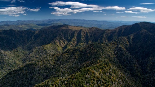
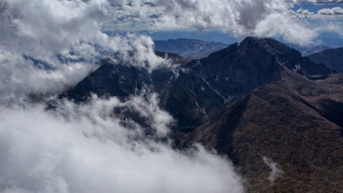
While in hot pursuit of the peaks over 6,000 feet in the Southeast, I found myself spending some time in Great Smoky Mountains National Park. On this particular day, lenticularis clouds developed, which are lens-shaped clouds that are caused by winds arcing through the atmosphere due to interactions with mountains. They are a good indication that the flight is going to be bumpy. I had the challenge of flying in extremely remote and forested terrain with no emergency options in the Smokies, coupled with what I call “Mr. Toad’s Wild Ride” in the sky.
From the book “Appalachian Altitude: Flying the Highest Peaks of the South.”