
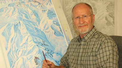
ThereтАЩs good chance that any time you slide off the top of a chairlift, youтАЩll be faced with╠¤тАЩs work. The 72-year-old Coloradan╠¤has╠¤hand-painted the maps used by╠¤more than 200 ski resorts. But skiingтАЩs most prolific artist says he stumbled into it by luck. In 1987, Niehues╠¤had just moved to Denver from Grand Junction, Colorado. He had a couple of kids, and he was looking for work as a graphic designer after his work at an auto-parts manufacturer dried up. He reached out to local artist Bill Brown, who gave him a one-off job working on the trail map for Winter ParkтАЩs Mary Jane Mountain. Brown, who was the only resort-map artist at the time, was looking to retire, and he passed the ski-map mantle on to Niehues.
Aside from ideal timing, Niehues says he thinks he has an innate ability to see a whole mountain in one shot. WeтАЩd have to agreeтАФhis maps are incredibly accurate, down to the parking lots, but with a nostalgic wash of pastel color╠¤thatтАЩs instantly recognizable.
Thanks to a ╠¤campaign that runs until January 3 (and has far exceeded its goal), he╠¤plans╠¤to release a book this summer╠¤showcasing╠¤three decadesтАЩ worth of work. Niehues╠¤told us about his book project, the mountains heтАЩs always wanted to draw, why you canтАЩt beat a hand-painted╠¤trail map, and how technology has changed his job for the better.
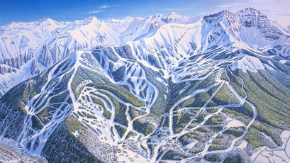
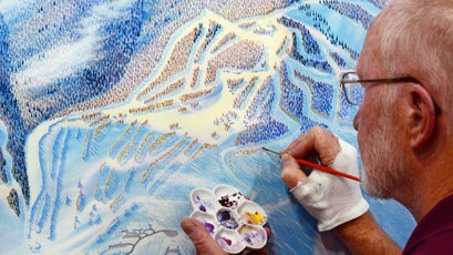
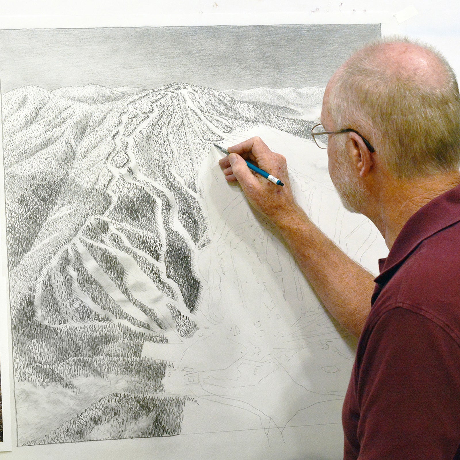
On His Process: тАЬI always fly over the mountain and photograph it. Today╠¤I can go in deep on Google, but aerial photography gives me an idea of what it looks like╠¤that I can quote from.╠¤Then the first step is to go into a small pencil sketch.╠¤If itтАЩs a complicated mountain, and I see different ways to illustrate it, IтАЩll send different thumbnails to clients. Then IтАЩll go into a comprehensive sketch that will be as big as the map. Once itтАЩs╠¤approved, IтАЩll project the image onto my painting surface, trace every detail, and then airbrush. I start with the sky and work from the top down filling in details.тАЭ
On the Details: тАЬItтАЩs a puzzle to put together. I struggled early on╠¤getting the back sides of mountains right. IтАЩm constantly trying to get all the flow lines╠¤correct and running down the page. Resorts know what they want and need, but sometimes they want to show their mountain bigger than it is. My job is to bring╠¤it back to reality.╠¤My favorite mountains are the ones where I can paint cliffs or rugged peaks and the mountains beyond. But I really like to do the mountains in New Zealand,╠¤because there are no trees there.тАЭ
On Skiing: тАЬI learned in ski in Europe when I was in the Army. A couple of us guys took leave and went to down to Switzerland. Mine╠¤was the fastest time down, so I thought I was pretty good. When I tried to ski again at Powderhorn, outside Grand Junction,╠¤after I came back in 1969, I╠¤walked off the mountain because I couldnтАЩt turn. On the job, I became an intermediate skier. ItтАЩs important, because I understand what other skiers go through in navigating the mountain.тАЭ
On the History of Ski Maps: тАЬThere are artists that have drawn a few maps, but there are really only two others who have done what I do. In the 1970s, Hal Shelton pioneered it here in the States. He was the first to paint trail maps, and╠¤he did it with an airbrush, because you can create subtle surfaces and lots of backlight. Bill Brown did it in the eighties, and then I took over for him. In the late nineties,╠¤everyone was looking at new technology because they thought computers could do a better job of mapping, but a lot of them have come back to my style. Now╠¤with the internet, itтАЩs so important to have a good image. YouтАЩve got a mountain thatтАЩs beautiful and challenging, and youтАЩve got to show that, and the computer images just arenтАЩt as beautiful. This is one thing that is better done the way it was done 50 years ago.тАЭ
On Anthologizing: тАЬWay back in the mid-nineties╠¤I started thinking that maybe IтАЩd have enough illustrations for a book, so I started working book rights into my contract. DidnтАЩt pursue it heavily, but╠¤then I started realizing, IтАЩm 72 now, so itтАЩs time to get it going.тАЭ
On Retirement: тАЬIтАЩve tried to retire, but then someone will call me and IтАЩve always wanted to do their mountain, so I end up jumping back in. IтАЩm doing a sketch of Mount Bachelor right now; they have 180 degrees of skiing, and IтАЩve always wanted to do that. An artist named╠¤, who is in Bozeman, Montana, is working as a prot├йg├й. He used to make maps with computers╠¤but realized he couldnтАЩt do it as well, so he went back to painting. There donтАЩt seem to be any others who are jumping into it. ItтАЩs a small market. It was a small market for me.тАЭ
On Art: тАЬI think of the paintings as art instead of trail maps. In the early days, it was really about the map, but the values have shifted. Hal and Bill realized it was important to get the beauty╠¤and to give people something they could look at and dream about. I think a computer-generated map is a reflection of the officeтАФitтАЩs rigid. A hand-painted map reflects the outdoors. You ski to get╠¤into that environment.тАЭ