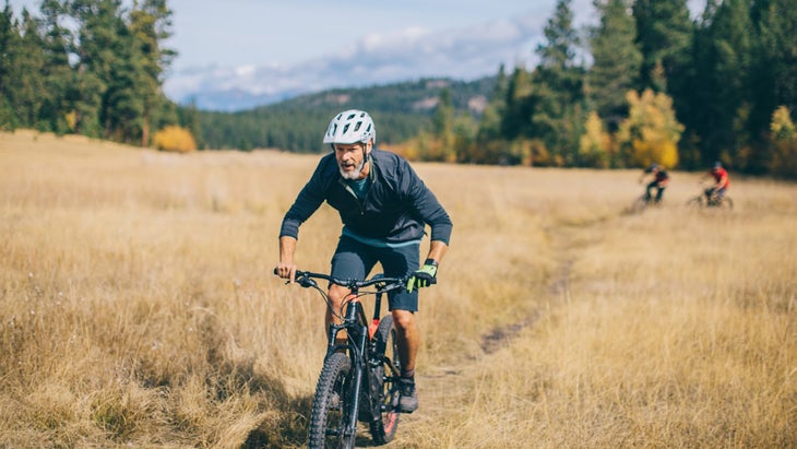
Bikepacking might be the perfect adventure. Ride bikes, sleep outside. It’s like bike touring, only dirtier since you’re camping and carrying all your gear on your bike, as opposed to staying in lodges and relying on your credit card for sustenance. I’ve been bikepacking for almost 20 years now, and continue to be entranced by its charm. Pedaling into the wilderness gives you a chance to experience more of the landscape than when you’re powered by foot. In some cases, you can get further away from civilization.
A few years ago, a bikepacking trip through Idaho became one of my favorite adventures. I linked together a handful of different backcountry hot springs while traversing some of the state’s most rugged singletrack, pedaling more than 70 miles. I wouldn’t have been able to cover half of that distance in that amount of time on foot.
Here are seven of the best bikepacking routes in America, some of which I’ve pedaled myself, while a few others remain firmly affixed to the top of my to-do list.
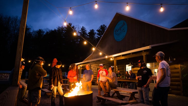
1. Singletrack and Waterfalls, Pisgah National Forest, North Carolina
Distance: 64 miles
Duration: Two to three days
Highlights: Singletrack descents, backcountry streams
With roughly 300 miles of singletrack and twice that distance in gravel roads, in North Carolina allows you to create all kinds of loop options. I recommend starting your journey at The Hub, a bike shop and beer garden at the entrance of Pisgah National Forest on 276, so you can get any last minute provisions you might need before you leave and finish the adventure with a beer when you’re done. Also, you can incorporate some of the forest’s signature singletrack, waterfalls, and swimming holes.
Follow the route of the mountain-bike race and you’ll hit a highlight reel of the area’s singletrack over 64 miles of trail and gravel. There are plenty of options to extend or shorten the route, too, but this is a solid introduction to what the mountains have to offer and 64 miles is the perfect two- to three-day adventure. Pisgah’s singletrack is technical and the climbs are steep, so don’t overestimate your ability in this forest. For instance, this route gains more than 10,000 feet of climbing. As a rule, I tell people to double the amount of time they think it will take them to pedal a mile in these mountains.
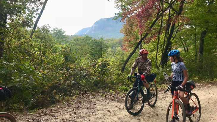
is about as flowy as Pisgah gets, with fast berms and plenty of rollers, while Black Mountain is a long, technical descent that draws cyclists from all over the country. Bring a fly rod and you can fish tight mountain streams, like North Mills River. There are good swimming holes on Bradley Creek, adjacent to Yellow Gap Road, too.
Where to camp: (from $35 a night) is a developed campground site along the river of the same name and is located near the start and finish of this route, but there are plenty of primitive, free campsites throughout the forest, especially on the gravel Yellow Gap Road, which helps form the backbone of this route.
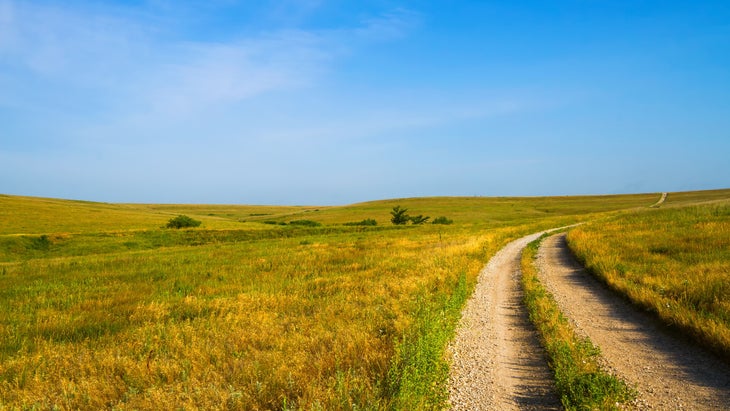
2. Flint Hills Trail State Park, Kansas
Distance: 96 miles point to point
Duration: Overnight or more
Highlights: Tallgrass prairie and farmland
When it’s finished, the will run 118 miles off-road from Osawatomie to Herington, making it one of the longest rail trails in the country. The last 20 miles or so are still a work in progress, but bikepackers can zero in on the 96 miles that are open from Osawatomie to Council Grove, offering a crushed limestone path that gets you away from traffic while passing through the largest expanse of tall grass prairie still standing in the U.S. The trail is open to bikes, foot traffic, and equestrians, so you might share space with the occasional horse.
The route only gains 1,880 feet along its entire length, so you can cover a lot of miles quickly, but you could also take your time and explore the small towns and rivers along the way. In fact, you can treat this as a civilized version of bikepacking, pedaling from coffee shop to ice cream shop.
The terrain is mostly farmland and rolling hills, but you can expect to pedal across several bridges, cruise along the Marais Des Cygnes River, which has the occasional bluff to shake up the view, and even pass a cave that outlaw Jesse James supposedly used as a hideout. There are inns, bike shops, restaurants, and campgrounds as it cruises through ten small towns, making this one of the most beginner friendly bikepacking routes in the country.
Where to camp: is roughly in the middle of the trail, offering great camping and access to the 4,000-acre reservoir. There are more than 240 sites to choose from in half a dozen different loops. Try to score a primitive site in the Waucondah Primitive Campground near the marina ($21 per night).
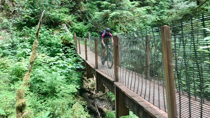
3. Olympic �����ԹϺ��� Trail, Olympic National Park, Washington
Distance: 65-mile out and back
Duration: Overnight
Highlights: Old growth forests and Lake Crescent
Another ongoing recreation path, Washington state’s Olympic Discovery Trail will be a cyclist’s dream one day. When it’s finished, the rail-grade trail will run for 130 miles from Port Townsend to the coast along the northern flank of the Olympic Peninsula. It’s currently about half done but bikepackers can enjoy the fully completed , a 25-mile singletrack alternative to the main path between the Elwha River and Lake Crescent. Combine it with the 11-mile , and you have a scenic 66-mile out and back in and around Olympic National Park. The terrain could double as the Forest Moon of Endor, the home planet of the Ewoks in Star Wars, with giant old growth evergreens, moss-covered everything and fields of tall ferns covering the forest floor. The route also skims the northern shore of Lake Crescent, an 11-mile long lake surrounded by green peaks within Olympic National Park.
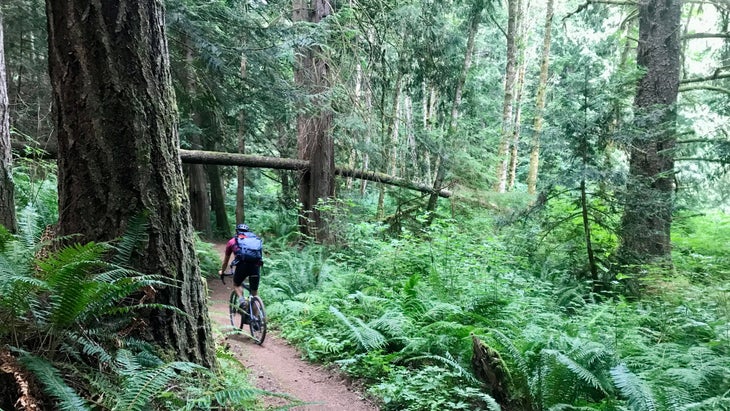
The route is a mix of paved rail trail (Spruce Railroad Trail) and buff single and double track (Olympic �����ԹϺ��� Trail), ideal for either a hard tail mountain bike or gravel bike with fat tires. I rode the Olympic �����ԹϺ��� Trail and some adjacent gravel and paved roads on a gravel bike while camping nearby, but it’s an ideal route for bikepacking with two developed campgrounds on the edge of Lake Crescent. If you hit it during the summer, you can even take a cool lake plunge; there’s a bridge over an inlet on Lake Crescent that makes for a cold, refreshing plunge that locals call the Devil’s Punchbowl.
Where to stay: is a National Park Service campground with 84 tent sites on the western edge of Lake Crescent ($24 a night). You’ll need reservations between May 15 and September 15 (which can be tough to get) but it’s first come/first serve outside of that window.
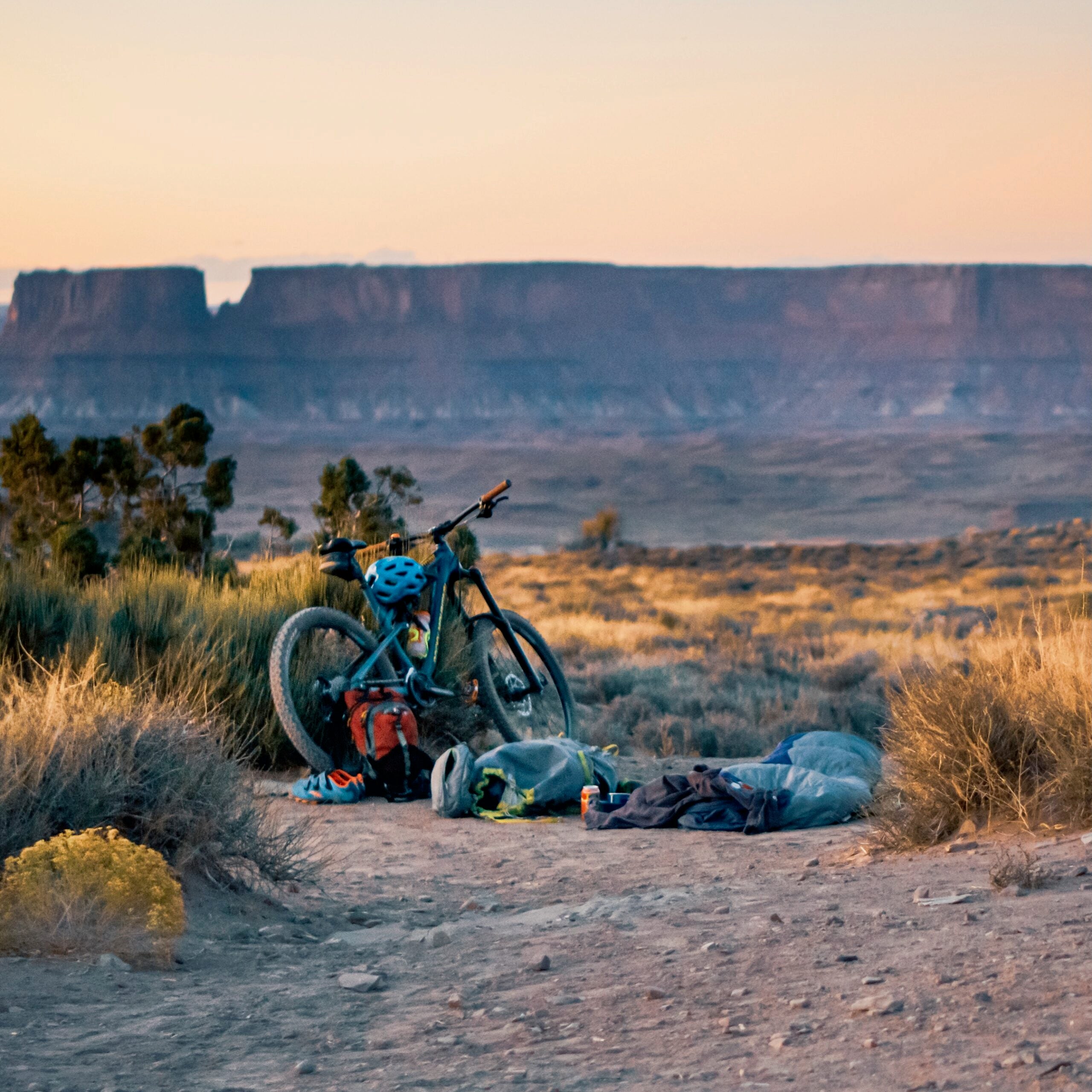
4. Idaho Hot Springs Route, Boise National Forest, Idaho
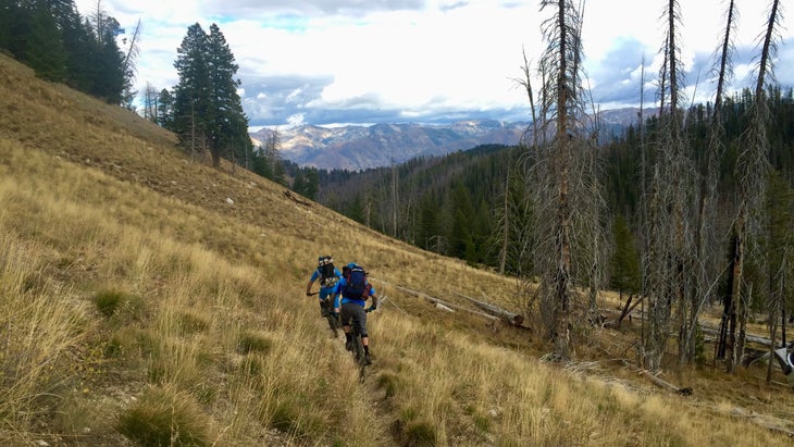
Distance: 70-mile loop
Duration: 3-4 days
Highlights: Hot springs!
The �����ԹϺ��� Cycling Association is a nonprofit that develops safe, long-distance bicycling journeys all across the country. The majority of these routes are paved, but they have made a few exceptions such as . This 518.5-mile loop through central Idaho has access to over 50 hot springs, and has two path options—one that traverses dirt roads and another that travels via lonely singletrack.
Several years ago, I rode a 70-mile loop that combined a piece of the main route and a singletrack option around the tiny towns of Featherville and Atlanta. It was a hard three to four days of riding, but each night ended with a soak in a backcountry pool of 100-plus degree water. You can recreate my adventure by combining the main route through Featherville with the , which passes through the historic and tiny mining outpost of Atlanta.
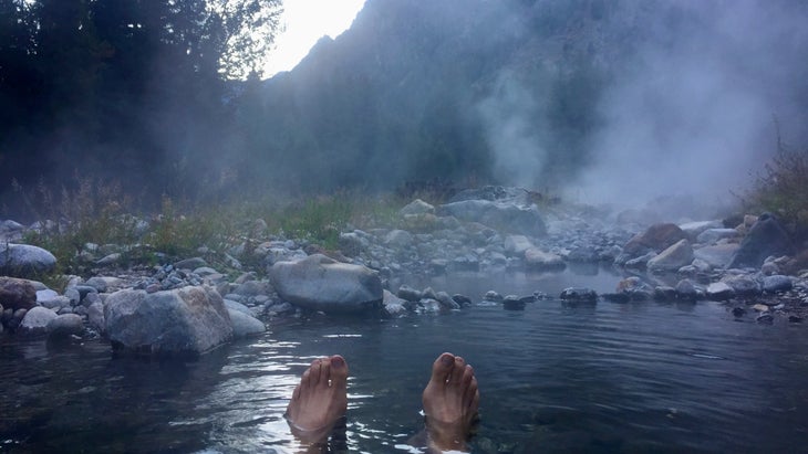
Much of the route follows the Middle Fork of the Boise River and Willow Creek, both of which are gorgeous backcountry streams. The terrain is tough, with long gravel road climbs and sinuous singletrack. Climbing to the top of Decker Creek Summit (8,800-foot tall) is a beast of an endeavor that involved a lot of hike-a-bike for me and my partners. But the 10-mile long downhill that followed is one of the longest and most enjoyable descents of my entire life. You’ll also have the chance to soak in several hot springs along the way. My favorite? Chattanooga Hot Springs, near the mining outpost of Atlanta, features a piping hot waterfall tumbling over a tan cliff into a shallow pool at its base.
Don’t attempt pedaling this route without buying both the Main Route and Singletrack Option maps from —not only will you be supporting a worthy nonprofit, but the maps will give you the best beta available with information about the various hot springs, general stores and terrain challenges throughout the adventure.
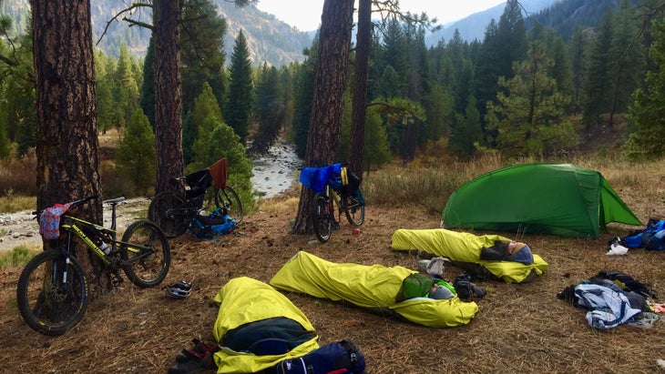
Where to stay: You’ll be choosing your own primitive campsites along this route, which travels within Boise National Forest. Choose a site with an established fire ring, and plan to pitch your tent along the rivers, which will give you the best chance of flat terrain.
5. Coconino Loop, Coconino National Forest, Arizona
Distance: 240 miles
Duration: Seven days
Highlights: Slick rock, canyons galore
The is 240 miles of singletrack and dirt roads through the canyons and peaks of Northern Arizona, combining some of the best trails and most spectacular terrain around Flagstaff and Sedona. It’s a difficult loop that hosts a bikepacking stage race that’s part of the burly , but serious mountain bikers should definitely put this route on their to-do list. Yes, you’ll climb 28,000 feet during your journey, but half of the route is made up of some of Arizona’s best singletrack, from the fast, flowy descent on the Arizona Trail into Flagstaff to the grippy slick rock that surrounds Sedona.
Go-getters will knock out this massive loop in four days during the stage race, but it’s best suited for a week-long epic, which will also give you time to hang out in Flagstaff and Sedona. The terrain is tough and you’re tackling serious elevation in the desert, so slower is probably better. The hike-a-bike up Mingus Mountain, which climbs 4,000 feet in 10 miles, is legendary. Don’t do this ride in the summer, as it’s too damn hot. But fall is perfect, and be sure to have the capacity to carry enough water for each day on the trail, especially if you’re taking your time between the towns, as finding fresh water in the desert can be tough.
Where to stay: There’s primitive camping throughout the Coconino and Kaibab National Forests throughout much of this route, but you’ll also have the chance to snag a hotel room or two, like the (from $100 a night), in the small town of Williams, which sits on Route 66.
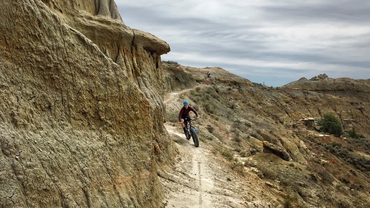
6. The Maah Daah Hey Trail, North Dakota
Distance: 100 miles
Duration: Four days
Highlights: Badlands scenery, remote terrain
The badlands of North Dakota earned their name ages ago, first by the Native Americans who lived in the region, and then by the European explorers that stumbled upon the landscape of canyons and buttes after traveling across the benign midwestern plains. I understand the hyperbolic nomenclature; I wouldn’t want to settle here either after passing through acres of fertile grasslands. But we have mountain bikes now, and pedaling through the gorges and cliffs created by ages of erosion sounds like a blast. And that’s exactly what you’ll get to do if you bikepack the 100-mile section of the between the north and south units of Theodore Roosevelt National Park.
The mostly singletrack route drops into deep creek drainages and climbs to the top of a multitude of buttes with moments of respite that offer long-range grassland views and the occasional stand of aspens for shade. Bighorn sheep and elk have been reintroduced to the area, so keep your eye out for wildlife.
Logistically, the Maah Daah Hey is pretty straightfoward: Multiple trailheads and access points give you the chance to create a distance and duration that suits your schedule, and there are established campgrounds with drinking water and safe places to pitch a tent throughout. While there’s water and camping to be found throughout, you’re in the middle of a complex of public lands so don’t expect any gas stations or restaurants along this route. You’ll need to bring all your gear and food with you. Offshoots of the trail allow you to create loops and check out nearby points of interest, like the Ice Caves, which are large overhangs in sandstone cliffs that have been known to hold ice into summer.
Go during the fall, which will make the stream crossings easier because of lower water. Or the summer when it’s warm enough that you’ll look forward to the deeper stream crossings.
Where to stay: There are nine along the Maah Daah Hey Trail, spaced roughly about 25 miles apart. Magpie Campground ($10 per night, first come-first serve) has good shade and is close to the Ice Caves Trail, so you can ditch your bags and pedal without all the weight for that excursion. Regardless of which campground you choose, the night skies in this area are reported to be legendary.
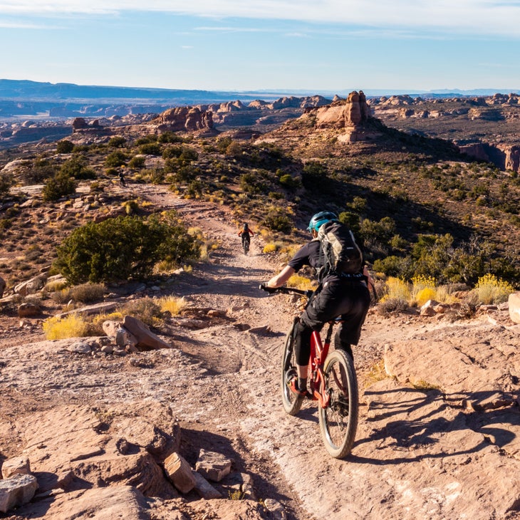
7. Kokopelli Trail, BLM, Colorado and Utah
Distance: 145 miles
Duration: Three days or more
Highlights: Canyons and the Colorado River
It’s hard to say what is the ultimate O.G. bikepacking route, but the , which runs from Fruita, Colorado, to Moab, Utah, is definitely in the conversation. It’s a classic, old–school route that combines mostly dirt road with some spicy singletrack through a mix of sandstone canyons and dusty plateaus along the Colorado River. There are moments of brilliant singletrack, particularly at the beginning near Fruita where the trails are buff, and the end near Moab where big slickrock and singletrack descents are earned, but mostly you’re pedaling lonely dirt roads with grand views of the La Sal Mountains on the horizon and the Colorado River below. While I’ve never ridden the Kokopelli from end to end, I’ve ridden bikes in this area multiple times and I’m always blown away by the scenery.
This is remote backcountry, so you need to be totally self-sufficient. Bring plenty of water (a lot of cyclists will cache water along the route) and a filter in case you need to pull from the Colorado River. There’s no food either, so pack what you want to eat. Plan this ride for spring or fall to make the most of mild weather. It would be near suicidal to attempt this big of a ride in the summer.
Finishing an epic adventure in the town of Moab is always fun, especially when the crescendo of the adventure includes ripping down the , an 11-mile technical descent with drops and epic views into the Castle Valley. There’s no shame in walking pieces of this trail, especially with a loaded down bike.
Where to stay: The majority of the route passes through Bureau of Land Management terrain, so you’ll have a mix of primitive, backcountry sites and established campgrounds throughout. , after you enter Utah, has half a dozen first-come-first-served sites on the Colorado River ($20 a night).
Graham Averill is �����ԹϺ��� magazine’s national parks columnist. Bikepacking is hands down his favorite adventure and is constantly planning his next route. He recently wrote about the best swimming holes in our national parks.